
Wave Run-Up Forecast : Waikīkī, Oʻahu
Attention: The forecast is not accurate when a tsunami, tropical storm or cyclone watch/warning is in effect. For these events, please seek information for either tsunamis or tropical storms/hurricanes. In case of a possible inundation event, please consult with local authorities and emergency responders to seek further information and direction.

The Solid Dark Blue Curve and Solid Cyan Curve display the Observed and Forecast Sea Level near Honolulu Harbor for the previous 3 days and the next 6 days, respectively, relative to Mean Lower Low Water (MLLW, a typical NOAA datum).
The Dotted Dark Blue Curve shows the estimated maximum height reached by waves along the shore at Waikīkī for the previous 3 days, relative to MLLW. The Dotted Cyan Curve shows the forecast height for the highest waves along the shore at Waikīkī for the next 6 days, relative to MLLW.
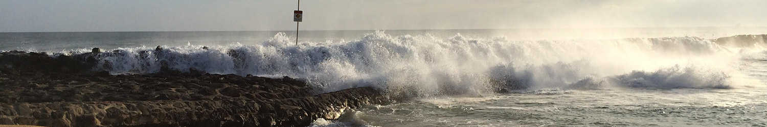
If the forecast run-up extends into the red shaded region on the plot, the waves are expected to at least become a disruption for beach activities. The higher the forecast the more severe the expected effects. One or more of the following threshold levels is/are shown in the red shaded area in the plot above: (a) Light Impacts, (b) Hazardous Impacts, (c) Critical Impacts. Click on the Examples Tab for descriptions of the possible hazards.
The PacIOOS Wave Run-Up Forecast is a tool to predict the potential occurrence of high sea levels and wave inundation impacting the shorelines of Waikīkī. Storm events, high waves, extreme tides, or a combination of these factors can lead to potential inundation.
The tool was developed to increase community resilience and enhance preparedness by providing decision-makers, agency representatives, hospitality industry, and community members with time to plan in advance of potential flooding events. The forecast is updated hourly (about 15 minutes after the hour) and dates and times are shown in local time.
The PacIOOS Wave Run-Up Forecast does not serve as a warning system. In case of a possible inundation event, please consult with local authorities and emergency responders to seek further information and direction. A similar forecast is also available for Oʻahu’s North Shore.
Contact
For more information, please contact Assaf Azouri. The Wave Run-Up Forecast Tool was developed by M. Guiles, D. Luther, and M. Merrifield within the Department of Oceanography in the School of Ocean and Earth Science and Technology (SOEST) at the University of Hawaiʻi at Mānoa.
Run-up Thresholds
(a) Light Impact – beach and nearshore activities disrupted as occasional waves may sweep the beach slopes or intermittently reach vegetation and artificial shoreline hardening structures.
(b) Hazardous Impact – heavy wave action on beaches and sweeping of the entire beach slope; likely run-up onto the parts of the coast that are not artificially hardened; battering of artificial shoreline hardening structures; occasional wave overtopping of artificial shoreline hardening structures; likely flooding of low lying areas and walkways; and/or erosion in vulnerable locations.
Run-up Examples
(a) Light Impact Event — July 12, 2018


Photo Credit: Hawaiʻi and Pacific Islands King Tides Project (yellow star on map).

Photo Credit: Hawaiʻi and Pacific Islands King Tides Project (green star on map).

Photo Credit: Hawaiʻi and Pacific Islands King Tides Project (pink star on map).

Photo Credit: Hawaiʻi and Pacific Islands King Tides Project (purple star on map).

Photo Credit: Hawaiʻi and Pacific Islands King Tides Project (purple star on map).

Photo Credit: Hawaiʻi and Pacific Islands King Tides Project (white star on map).

Photo Credit: Hawaiʻi and Pacific Islands King Tides Project (white star on map).

Photo Credit: Hawaiʻi and Pacific Islands King Tides Project (white star on map).

Photo Credit: Hawaiʻi and Pacific Islands King Tides Project (white star on map).

Photo Credit: Hawaiʻi and Pacific Islands King Tides Project (gray star on map).

Photo Credit: Hawaiʻi and Pacific Islands King Tides Project (gray star on map).

Photo Credit: Hawaiʻi and Pacific Islands King Tides Project (gray star on map).
(a) Light Impact Event — August 8-9, 2018


Photo Credit: Hawaiʻi and Pacific Islands King Tides Project (blue star on map).

Photo Credit: Hawaiʻi and Pacific Islands King Tides Project (blue star on map).

Photo Credit: Hawaiʻi and Pacific Islands King Tides Project (pink star on map).

Photo Credit: Hawaiʻi and Pacific Islands King Tides Project (pink star on map).

Photo Credit: Hawaiʻi and Pacific Islands King Tides Project (dark blue star on map).
(a) Light Impact Event — July 1-4, 2019


Photo Credit: Hawaiʻi and Pacific Islands King Tides Project (yellow star on map).

Photo Credit: Hawaiʻi and Pacific Islands King Tides Project (yellow star on map).

Photo Credit: Hawaiʻi and Pacific Islands King Tides Project (orange star on map).

Photo Credit: Hawaiʻi and Pacific Islands King Tides Project (orange star on map).

Photo Credit: Hawaiʻi and Pacific Islands King Tides Project (orange star on map).

Photo Credit: Hawaiʻi and Pacific Islands King Tides Project (purple star on map).

Photo Credit: Hawaiʻi and Pacific Islands King Tides Project (purple star on map).

Photo Credit: Hawaiʻi and Pacific Islands King Tides Project (white star on map).

Photo Credit: Hawaiʻi and Pacific Islands King Tides Project (white star on map).

Photo Credit: Hawaiʻi and Pacific Islands King Tides Project (white star on map).

Photo Credit: Hawaiʻi and Pacific Islands King Tides Project (white star on map).

Photo Credit: Hawaiʻi and Pacific Islands King Tides Project (gray star on map).

Photo Credit: Hawaiʻi and Pacific Islands King Tides Project (dark blue star on map).
(b) Hazardous Impact Event — May 24-27, 2017


Photo Credit: Hawaiʻi and Pacific Islands King Tides Project (blue star on map).

Photo Credit: Hawaiʻi and Pacific Islands King Tides Project (blue star on map).

Photo Credit: Hawaiʻi and Pacific Islands King Tides Project (blue star on map).

Photo Credit: Hawaiʻi and Pacific Islands King Tides Project (yellow star on map).

Photo Credit: Hawaiʻi and Pacific Islands King Tides Project (yellow star on map).

Photo Credit: Hawaiʻi and Pacific Islands King Tides Project (yellow star on map).

Photo Credit: Hawaiʻi and Pacific Islands King Tides Project (yellow star on map).

Photo Credit: Hawaiʻi and Pacific Islands King Tides Project (orange star on map).

Photo Credit: Hawaiʻi and Pacific Islands King Tides Project (orange star on map).

Photo Credit: Hawaiʻi and Pacific Islands King Tides Project (orange star on map).

Photo Credit: Hawaiʻi and Pacific Islands King Tides Project (orange star on map).

Photo Credit: Hawaiʻi and Pacific Islands King Tides Project (orange star on map).

Photo Credit: Hawaiʻi and Pacific Islands King Tides Project (orange star on map).

Photo Credit: Hawaiʻi and Pacific Islands King Tides Project (orange star on map).

Photo Credit: Hawaiʻi and Pacific Islands King Tides Project (orange star on map).

Photo Credit: Hawaiʻi and Pacific Islands King Tides Project (green star on map).

Photo Credit: Hawaiʻi and Pacific Islands King Tides Project (pink star on map).

Photo Credit: Hawaiʻi and Pacific Islands King Tides Project (pink star on map).

Photo Credit: Hawaiʻi and Pacific Islands King Tides Project (pink star on map).

Photo Credit: Hawaiʻi and Pacific Islands King Tides Project (purple star on map).

Photo Credit: Hawaiʻi and Pacific Islands King Tides Project (purple star on map).

Photo Credit: Hawaiʻi and Pacific Islands King Tides Project (purple star on map).

Photo Credit: Hawaiʻi and Pacific Islands King Tides Project (purple star on map).

Photo Credit: Hawaiʻi and Pacific Islands King Tides Project (white star on map).

Photo Credit: Hawaiʻi and Pacific Islands King Tides Project (white star on map).

Photo Credit: Hawaiʻi and Pacific Islands King Tides Project (white star on map).

Photo Credit: Hawaiʻi and Pacific Islands King Tides Project (white star on map).

Photo Credit: Hawaiʻi and Pacific Islands King Tides Project (gray star on map).

Photo Credit: Hawaiʻi and Pacific Islands King Tides Project (gray star on map).

Photo Credit: Hawaiʻi and Pacific Islands King Tides Project (gray star on map).

Photo Credit: Hawaiʻi and Pacific Islands King Tides Project (neon yellow star on map).

Photo Credit: Hawaiʻi and Pacific Islands King Tides Project (neon yellow star on map).

Photo Credit: Hawaiʻi and Pacific Islands King Tides Project (neon yellow star on map).

Photo Credit: Hawaiʻi and Pacific Islands King Tides Project (dark blue star on map).

Photo Credit: Hawaiʻi and Pacific Islands King Tides Project (dark blue star on map).
(b) Hazardous Impact Event — June 23, 2017


Photo Credit: Hawaiʻi and Pacific Islands King Tides Project (purple star on map).

Photo Credit: Hawaiʻi and Pacific Islands King Tides Project (purple star on map).

Photo Credit: Hawaiʻi and Pacific Islands King Tides Project (purple star on map).

Photo Credit: Hawaiʻi and Pacific Islands King Tides Project (purple star on map).

Photo Credit: Hawaiʻi and Pacific Islands King Tides Project (purple star on map).

Photo Credit: Hawaiʻi and Pacific Islands King Tides Project (gray star on map).
(b) Hazardous Impact Event — August 1, 2019


Photo Credit: Hawaiʻi and Pacific Islands King Tides Project (dark blue star on map).

Photo Credit: Hawaiʻi and Pacific Islands King Tides Project (dark blue star on map).

Photo Credit: Hawaiʻi and Pacific Islands King Tides Project (dark blue star on map).
(b) Hazardous Impact Event — July 3-4, 2020


Photo Credit: Hawaiʻi and Pacific Islands King Tides Project (blue star on map).

Photo Credit: Hawaiʻi and Pacific Islands King Tides Project (blue star on map).

Photo Credit: Hawaiʻi and Pacific Islands King Tides Project (yellow star on map).

Photo Credit: Hawaiʻi and Pacific Islands King Tides Project (yellow star on map).

Photo Credit: Hawaiʻi and Pacific Islands King Tides Project (yellow star on map).

Photo Credit: Hawaiʻi and Pacific Islands King Tides Project (purple star on map).

Photo Credit: Hawaiʻi and Pacific Islands King Tides Project (purple star on map).

Photo Credit: Hawaiʻi and Pacific Islands King Tides Project (purple star on map).

Photo Credit: Hawaiʻi and Pacific Islands King Tides Project (purple star on map).

Photo Credit: Hawaiʻi and Pacific Islands King Tides Project (white star on map).

Photo Credit: Hawaiʻi and Pacific Islands King Tides Project (white star on map).

Photo Credit: Hawaiʻi and Pacific Islands King Tides Project (gray star on map).

Photo Credit: Hawaiʻi and Pacific Islands King Tides Project (gray star on map).

Photo Credit: Hawaiʻi and Pacific Islands King Tides Project (gray star on map).

Photo Credit: Hawaiʻi and Pacific Islands King Tides Project (gray star on map).

Photo Credit: Hawaiʻi and Pacific Islands King Tides Project (gray star on map).

Photo Credit: Hawaiʻi and Pacific Islands King Tides Project (gray star on map).
(b) Hazardous Impact Event — July 18, 2020


Photo Credit: Hawaiʻi and Pacific Islands King Tides Project (yellow star on map).

Photo Credit: Hawaiʻi and Pacific Islands King Tides Project (yellow star on map).
Photo Credit: Hawaiʻi and Pacific Islands King Tides Project (yellow star on map).

Photo Credit: Hawaiʻi and Pacific Islands King Tides Project (orange star on map).

Photo Credit: Hawaiʻi and Pacific Islands King Tides Project (orange star on map).

Photo Credit: Hawaiʻi and Pacific Islands King Tides Project (green star on map).

Photo Credit: Hawaiʻi and Pacific Islands King Tides Project (green star on map).

Photo Credit: Hawaiʻi and Pacific Islands King Tides Project (green star on map).

Photo Credit: Hawaiʻi and Pacific Islands King Tides Project (pink star on map).

Photo Credit: Hawaiʻi and Pacific Islands King Tides Project (purple star on map).

Photo Credit: Hawaiʻi and Pacific Islands King Tides Project (purple star on map).

Photo Credit: Hawaiʻi and Pacific Islands King Tides Project.

Photo Credit: Hawaiʻi and Pacific Islands King Tides Project (purple star on map).

Photo Credit: Hawaiʻi and Pacific Islands King Tides Project (white star on map).

Photo Credit: Hawaiʻi and Pacific Islands King Tides Project (gray star on map).

Photo Credit: Hawaiʻi and Pacific Islands King Tides Project (gray star on map).

Photo Credit: Hawaiʻi and Pacific Islands King Tides Project (gray star on map).

Photo Credit: Hawaiʻi and Pacific Islands King Tides Project (gray star on map).

Photo Credit: Hawaiʻi and Pacific Islands King Tides Project (gray star on map).

Photo Credit: Hawaiʻi and Pacific Islands King Tides Project (gray star on map).
Photo Credit: Hawaiʻi and Pacific Islands King Tides Project(dark blue star on map).
Description of Waikīkī Wave Run-Up Forecast
The Solid Dark Blue Curve and Solid Cyan Curve display the Observed and Forecast Sea Level at Honolulu Harbor (Pier 4) for the previous 3 days and the next 6 days, respectively, relative to Mean Lower Low Water (MLLW, a typical NOAA datum). This tidal sea level variation and forecast captures most of the slowly changing sea level (without taking short period wind and swell waves into consideration) within 5 miles of Honolulu Harbor. The forecast is updated every 4 hours. Read more details about the components of the Observed and Forecast Sea Level.
The Dotted Dark Blue Curve shows the estimated maximum height reached by waves along the shore at Waikīkī for the previous 3 days, relative to MLLW. The Dotted Cyan Curve shows the forecast height for the highest waves along the shore at Waikīkī for the next 6 days, relative to MLLW. These heights are equal to the Observed/Forecast Sea Level plus the Estimated/Forecast Wave Run-Up Height described below (estimated Black Dots; forecast Gray Dots).
If the forecast run-up extends into the red shaded region on the plot, the waves are expected to at least become a disruption for beach activities. The higher the forecast the more severe the expected effects. Click on the Examples tab for descriptions of the possible hazards.
Components of Waikīkī Wave Run-Up Forecast

The Black Dots display the Estimated Wave Run-Up Height for the previous 3 days, measured relative to the Observed Sea Level described above. The Wave Run-Up Height is a simple, empirically-determined function of the three quantities plotted in the bottom plot and described below. All three quantities are estimated from the observed sea and swell Off-Shore Gravity Wave Height, shown as the Dark Violet Line in the above plot (note that the mean value of all—estimated plus forecast—gravity wave heights has been subtracted from the wave height variables in this plot to simplify the plot). Forecast and observed gravity wave height (denoted Hs) is the mean of the largest 1/3 waves recorded during the sample period.
The Gray Dots display the Forecast Wave Run-Up Height for the next 6 days, relative to the Forecast Sea Level described above. The Forecast Wave Run-Up Height is a simple, empirically-determined function of the three forecast quantities plotted in the bottom plot and described below. All three quantities are forecast from the sea and swell Forecast Off-Shore Gravity Wave Height, shown as the Light Violet Line in the above plot (note that the mean value of all—estimated plus forecast—gravity wave heights has been subtracted from the wave height variables in this plot to simplify the plot).

This plot displays estimates and forecasts of the three quantities that determine the Estimated and Forecast Wave Run-Up Heights shown in the previous plot. The estimated quantities are based on empirical formulas applied to the observed Off-Shore Gravity Wave Height for the previous 3 days, while the forecast quantities are based on these same formulas applied to the Forecast Off-Shore Gravity Wave Height for the next 6 days.
Dark Red (Pink) Dots – Estimated (forecast) sea level “set-up,” which we will call SU.
Dark Orange (Light Orange) Dots – Estimated (forecast) maximum short-period (2-30 seconds) gravity wave swash height, which we will call SGW.
Dark Green (Light Green) Dots – Estimated (forecast) long-period (2-20 minute) gravity wave height, which we will call LGW.
Given these quantities, the estimated and forecast wave run-up heights are calculated as follows.
Estimated Wave Run-Up Height equals
1.2 x ( SU + 0.5 x sqrt( LGW^2 + SGW^2 ) )
Forecast Wave Run-Up Height equals
1.2 x ( SU + 0.5 x sqrt( LGW^2 + SGW^2 ) )
An archive of previous forecast plots can be accessed below. Select a day of interest from the calendar, or use the slider tool to quickly navigate through all available images. Two historical forecast plots are provided for each day, generated at 6:00 AM and 6:00 PM of the local time zone. To view the most recent forecast and to learn more about the different components of the graph, please go to the Forecast tab.
date: :
Loading archive...


