WaveWatch III (WW3) and Simulating Waves Nearshore (SWAN) Wave Models
Global WW3 Model
Through a collaborative effort with NOAA/NCEP and NWS Honolulu, the Department of Ocean and Resources Engineering at the University of Hawai‘i has implemented a global scale WW3 model. The global model is initialized daily and is forced with NOAA/NCEP's global forecast system (GFS) winds. This model is designed to capture the large scale ocean waves, provide spectral boundary conditions for the Hawai‘i and Mariana Islands regional WW3 model, and most importantly, the 7 day model outputs a 5 day forecast.
Hawaiian Islands Wave Models

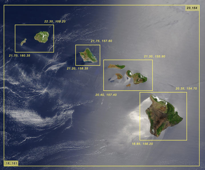
Boundaries of the model regions are outlined in yellow. The larger box outlines the Hawai‘i WW3 model, and the four smaller boxes represent the SWAN model regions. The latitude and longitude degrees are labeled at the boundary corners.
Main Hawaiian WW3 Model (Regional Scale)
The Global WW3 model provides boundary conditions for the Main Hawaiian WW3. The primary purpose of the regional model is to capture the island effects such as island shadowing, refraction, and accurate modeling of local wind waves. Hawai‘i WW3 is forced with winds from University of Hawai‘i Meteorology department operational 7.5 day mesoscale model, which has a more suitable spatial resolution than the global scale wind field. Similar to Global WW3, Hawai‘i WW3 is run daily directly after Global WW3 and also provides a 5 day forecast. Hawai‘i WW3 is used to further nest into nearshore island scale models, as described below.
Kaua‘i, O‘ahu, Maui County, and the Hawai‘i Island SWAN Models (Island Scale)
In order to capture the shallow water effects and the nearshore coastal dynamics such as refracting, shoaling, and smaller scale shadowing, a high resolution SWAN model is utilized to provide a 5 day forecast. The SWAN models have the following approximate resolutions: Kaua‘i- 500 meters; O‘ahu- 500 meters; Maui County- 1 kilometer; Hawai‘i Island- 1 kilometer. These models are run directly after Hawai‘i WW3 has completed.

Boundaries of the model regions are outlined in yellow. There are two regional models for Hawai‘i, the Northwestern Hawaiian Islands (described in the paragraph below) and the Main Hawaiian Islands (described in the paragraphs above).
Northwestern Hawaiian WW3 Model (Regional Scale)
The Global WW3 model provides boundary conditions for the Northwestern Hawaiian WW3. Similar to the Main Hawaiian WW3, the primary purpose of the model is to capture the island effects such as island shadowing, refraction, and accurate modeling of local wind waves by providing a 7 day model with hourly forecast of 5 days with approximately 5 kilometer resolution. The model is forced with winds from University of Hawai‘i Meteorology department's operational model, which has a more suitable spatial resolution than the global scale wind field.
Mariana Islands Wave Models

Boundaries of the model regions are outlined in yellow. The larger box outlines the Mariana Islands WW3 model, and the two smaller boxes represent the SWAN model regions. The inset image provides a close up of the Apra Harbor model in Guam.
Mariana Islands WW3 Model (Regional Scale)
The Global WW3 model provides boundary conditions for the Mariana WW3, and the model is forced with NOAA/NCEP's global forecast system (GFS) winds. The 5 kilometer resolution allows for the model to capture more wave detail than the larger global model. Mariana WW3 is run daily directly after the Global WW3 and provides a 7 day model output with a 5 day forecast. In addition, Mariana WW3 is used to further nest into nearshore island scale models, as describe below.
Guam Island and Apra Harbor SWAN Models (Island and Local Scale)
The high resolution island scale models provide detailed wave information important for activities in coastal areas such as, the transportation of large vessels entering and leaving Apra Harbor. The Guam Island SWAN model is forced with boundary conditions from the Mariana WW3 and has a resolution of approximately 500 meters. The Guam SWAN model is then used as the boundary conditions for the Apra Harbor SWAN model. The Apra Harbor model has a resolution of approximately 50 meters.
Samoa Wave Models

Boundaries of the model regions are outlined in yellow. The larger box outlines the Samoa WW3 model, and the smaller box represents the Tutuila SWAN model region.
Samoa WW3 Model (Regional Scale)
The Global WW3 model provides boundary conditions for the Samoa WW3 model. This model has a resolution of 5 kilometers and provides 7 days of model output with a 5 day forecast, allowing for analysis of oceanographic island effects in this region.
Tutuila SWAN Model (American Samoa Island Scale)
The Tutuila SWAN Model is run immediately after the Samoa WW3 Model run is completed, and the model uses the Samoa Model for boundary conditions for the 7 day model with 5 day hourly forecast. The resolution of 500 meters is useful for capturing shallow water effects and nearshore coastal dynamics.
*Please note that certain nested model setups are still in the testing and validation phase. While considerable effort has been made to implement all model components in a thorough, correct, and accurate manner, numerous sources of error are possible. As such, please use this data with the caution appropriate for any ocean related activity.


